
O CIRCUIT - PATAGONIA
DISTANCE
117 KM
DIFFICULTY (1-10)
7
DAYS
7
HIGH POINT
1200 MT
TREKKER
Carolina Isella

Towards the end of the world: Patagonia
I have been to one of the most sought-after lands by mountain lovers.
Now I understand why.
Patagonia captivates you and makes you think of nothing but the present time. However, I would like to point out that this place has nothing to envy to italian Dolomites, fix it in the head. In terms of trekking, it is not one of those very demanding destinations, considering that the highest point reached during the famous “O Circuit” trekking in the Torres del Paine Park is just over 1200mt, but instead you have to fear the continuous climate changes and the constant wind. So if you are undecided, organize as soon as you can. There are different routes for all age groups and all levels of fitness, so don’t worry. In addition, there are also daily tours if you only want to see certain things, but the advice I give you, given the endless hours of flight to get there from Europe, is to take the right time to go trekking in peace. . Now let’s talk more specifically about the “O Circuit” trekking, one of the most famous in the world. It is in fact located in one of the protected areas of Chile, one of the largest parks in the country, one of the most important, the third park in the country by number of visits and recognized as a UNESCO protected property. We are talking about the Torres del Paine National Park.
I know that you TripInYourShoes readers are lovers of flora and fauna. Unfortunately, I am not so well informed, what I can tell you, however, is that Patagonia from these points of view is very varied and abundant.
When I was in Puerto Natales, which was our pre / post trekking stop, some local people told me that all the citizens are very attentive to their surroundings and they know how much preserving the nature around them brings them only good effects, both physically / mentally and economically.


Day 1:
From Central Sector to Camp Serón 13km +/- 150mt – 4 / 5h
After arriving in Puetro Natales and taking a bus to the start of the park, the real adventure begins. This first day is nothing tiring, you will cross a forest of southern beech trees and you will see long expanses of green surrounded by mountains. We then pass alongside the Paine River which will accompany you for the next 2 days. Once you arrive at the campsite, be sure to pitch your tent right away, if you have one with you, because the space isn’t that much.
Day 2:
From Camp Serón to Camp Dickson 18km +/- 200mt – 6 / 7h
I remember I particularly liked this second stage, even if it started with a snowstorm we were not at all organized, so don’t do as we do, but bring everything you need for every climatic situation. This day takes you to the most hidden part of the park and the closest to the border with Argentina. Although it is a long stage, it is quite simple because you will only find one climb in the whole day and from the top of which you can enjoy a beautiful view of Lake Paine. After about 3 / 3.5 hours you will find the Coiron rest area where you can eat and rest and then resume the route, all flat, between marshy areas and wide fields until you see Lake Dickson and its glacier.


Day 3:
From Camp Dickson to Camp Los Perros 12 km – + 450mt- 4 / 5h
Progressively you go higher and higher up to Los Perros lake fed by its glacier which will majestically emerge in front of you once the last climb of the day is over. The campsite is the most rustic of the park without showers and heated areas, and only with the possibility of sleeping in a tent.
4th day:
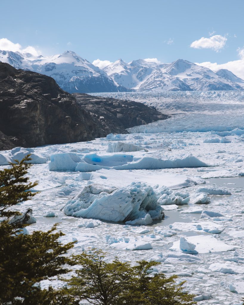
From Camp Los Perros to Camp Gray 27 km – + 650 / -1100mt – 9 / 10h
We arrived at the halfway point and on the most intense day of the circuit, both physically and mentally. Being very long as a stage, the advice is to get up early (around 5) and start walking so as not to arrive too late at your destination. You pass through suggestive landscapes in the middle of the bush until you reach a rocky path where the 3-3.5 hour climb begins which will take you up to 1200mt. I admit that you will arrive up quite tired, but all will be rewarded by the sight of the Gray Glacier. The path continues descending rapidly and re-entering the bush until it reaches the first stop, the Paso campsite (we caught it closed) where we stopped only to eat and leave again after 1 hour. From here you will walk another 3 hours crossing 3 suspension bridges and with a breathtaking landscape that will accompany you to the Gray campsite.
5th day:
From Camp Gray to Camp Paine Grande 11km +/- 250mt – 3 / 4h
This stage is very light, you will finally say, after 10 hours of walking we deserve it, yes I said it too while I was there. I recommend that you take it easy and enjoy the view of the Gray Glacier as long as you can, but once you arrive at Camp Paine Grande you will have another no less impressive one on Lake Pehoé.


Day 6:
From Camp Paine grande to Camp Francés 17km + junction to the Mirador Britannico + 5,4km – 3h
Although the previous stage was not so demanding, I know you will be tired, but you absolutely must not miss the British Mirador, it will be a bit tiring, but I will tell you a secret: you can leave your backpack at the Italian Camp and go up and down without weight . Trust that it will be one of the most beautiful sensations ever and then, let me tell you, the sight repays all the tiredness. I don’t want to tell you too much, let yourself be carried away by the path and enjoy the sweeping views, then you will thank me. After getting off and returning to the Italian Camp, it will take you 1 hour to get to Camp Francés.
Day 7:
From Camp Francés to Central Sector 13km – 4 / 5h
The last day if you want you could extend the trip and go to Camp Chileno, but unfortunately it went badly for us due to bad weather. You will arrive at this stage tired, even if with a slightly lighter backpack since all the food will be practically finished. It is a light walk, very flat and completely landscaped, you will pass several streams, on your right you will see the beginning and end of the Nordenskjöld lake and you will feel small in the midst of green expanses. Enjoy it.

- The O Circuit develops in one of the most beautiful protected areas of entire South American continent: the Torres del Paine National Park
- The altitude is always quite low, reaching a maximum of 1200 meters above the sea level. We recommend taking an excursion to the British Mirador, to enjoy a landscape with wild and unspoiled connotations
- Various equipped area are set up for the night. The advice is to take them into consideration for the organization of the various stages
- Camp Dickson is located near the omonimous lake. In this area it is easy to connect with the surrounding nature, especially at sunrise and sunset
- It is advisable to check well before departure and plan the places where you want to stay overnight
- E’ possibile affrontare l’O Circuit con la tenda personale. E’ un’opzione che può avere risvolti comodi, a patto di essere disposti a camminare con un peso maggiore sulle spalle
- Bringing freeze-dried fruit, cans, a gas stove and a tin can certainly be a suitable way to save money. It is advisable to have plenty of dried fruit, a source of energy in the medium term. It can be purchesed in Puerto Natales.
- During all stages there is a good availability of drinking water. Several streams in the area provide watering, being pratically uncontamined
- To move along the path we used the Map.me app, very convenient. The map of the area must be downloaded previously, and later it can also be used in offline mode